Vidette Meadow Backpacking

Kings Canyon National Park

Vidette Meadow with East Vidette and West Vidette peaks, Kings Canyon National Park, California

Vidette Meadow Backpacking

Kings Canyon National Park


Vidette Meadow

Kings Canyon National Park

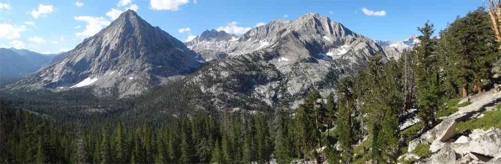
Vidette Meadow stretches along Bubbs Creek more than a dozen miles from Cedar Grove in Kings Canyon National Park. The John Muir Trail passes beside Vidette Meadow, making it a popular camping place for hikers. Lower Vidette Meadow is less than a mile downstream, just beyond the John Muir Trail. The lower meadow is along the popular Rae Lakes Loop trail. Both meadows are guarded by two prominent peaks (shown above), West Vidette and East Vidette.

Lower Vidette Meadow, Kings Canyon National Park, California

Lower Vidette Meadow

Anglers find great fishing along Bubbs Creek where it meanders through the meadows and both above and below the meadows in pools and riffles. Vidette Meadow makes a great base camp for exploring surrounding highlights such as Charlotte Lake, Bullfrog Lake, Glen Pass, and the upper Bubbs Creek Valley.
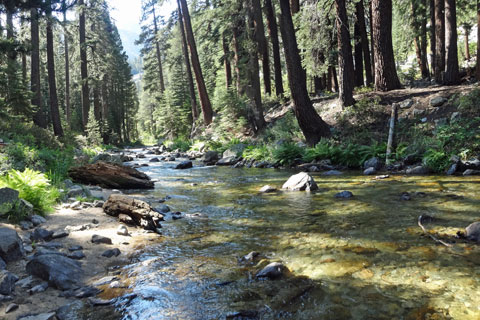
Bubbs Creek, Kings Canyon National Park, California

Bubbs Creek

Wildlife

Bears were once notorious for stealing hikers' food in Vidette Meadow, but no longer. The use of bear canisters and bear boxes has changed all that. Deer are commonly seen around Vidette Meadow and along the Bubbs Creek trail. Rattlesnakes are more common along the Bubbs Creek trail than many other parts of the Rae Lakes Loop. Likely you will not see one, but always be vigilant.

Mosquitoes thrive in meadow areas in early and mid-summer. By late August and through September they are usually not a problem.

Vidette Meadow - Key Facts


Location: Kings Canyon National Park, 80 miles east of Fresno
Trailhead: Road's End in Cedar Grove, elevation 5,035 feet
Lower Vidette Meadow elevation: 9,490 feet
Elevation Gain: 4,455 feet
Hiking Distance: 13 miles (to Lower Vidette Meadow)
Best seasons: Summer through fall
Campsites: Excellent sites from lower to upper Vidette


sign to Vidette Meadow, 13 miles
Road's End Ranger Station, Cedar Grove, Kings Canyon National Park, California

Road's End Ranger Station, Cedar Grove


Trekking Poles


Vidette Meadow - Key Facts


Location: Kings Canyon National Park, 80 miles east of Fresno
Trailhead: Road's End in Cedar Grove, elevation 5,035 feet
Lower Vidette Meadow elevation: 9,490 feet
Elevation Gain: 4,455 feet
Hiking Distance: 13 miles (to Lower Vidette Meadow)
Best seasons: Summer through fall
Campsites: Excellent sites from lower to upper Vidette


sign to Vidette Meadow, 13 miles

Vidette Meadow Trailhead
Road's End - Cedar Grove

Hikers start their journey to Vidette Meadow at Road's End Trailhead in Cedar Grove, 38 miles from the entrance to Kings Canyon National Park. The wilderness permit office is situated alongside the trail near the parking lot.

Rangers at the office will issue you a wilderness permit. Since the Rae Lakes Loop trails are popular, be sure you have made a reservation if you are hiking at peak times. Park in the nearby overnight parking area. Do not leave anything in your car that will attract bears. Bear boxes are located adjacent to the parking area. Restrooms are available.


Nearby Camping and Lodging

In nearby Cedar Grove you will find several large campgrounds. In the summer it is wise to have a reservation if you plan to camp there. Lodging is available at the Cedar Grove Lodge. A snack bar is open for breakfast, lunch, and dinner during the summer. Next door is a gift shop and market. Showers are also available.

More campgrounds, lodging, stores, a post office, and restaurant are found 35 miles back at Grant Grove.

The Cedar Grove Pack Station is located near Cedar Grove Village.