Tuolumne Meadows to Devils Postpile Camping

Along the John Muir Trail

Banner Peak, Yosemite National Park, California

Tuolumne Meadows to Devils Postpile Camping

Along the John Muir Trail


Camping along the John Muir Trail

Backpackers leaving Tuolumne Meadows and heading up Lyell Canyon must hike at least 4 miles before setting up camp. Sites can be found back among the trees here and there along the valley all the way the foot of the earnest climbing up Donohue Pass. Many hikers like to push on to the area around the footbridge to set up their camp, giving them a good head-start on the next day's climb up the pass.
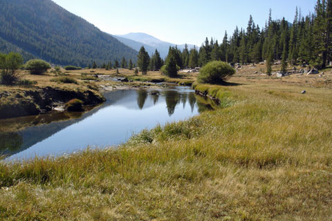
Lyell Canyon, Yosemite National park, California

Lyell Canyon


Shop Amazon for:
Backpacking Tents

Once across Donohue Pass, good campsites become scarce for 2½ miles until the trail joins Rush Creek. There, good campsites can be found among the trees. Farther down the trail climbing over Island Pass trees are sparse and running water is often not available.

Thousand Island Lake, Ansel Adams Wilderness, California

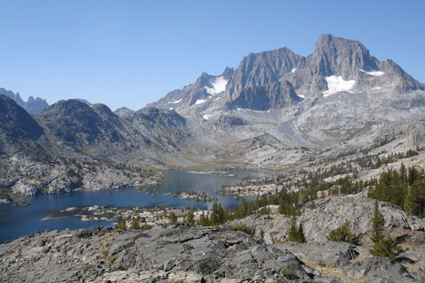
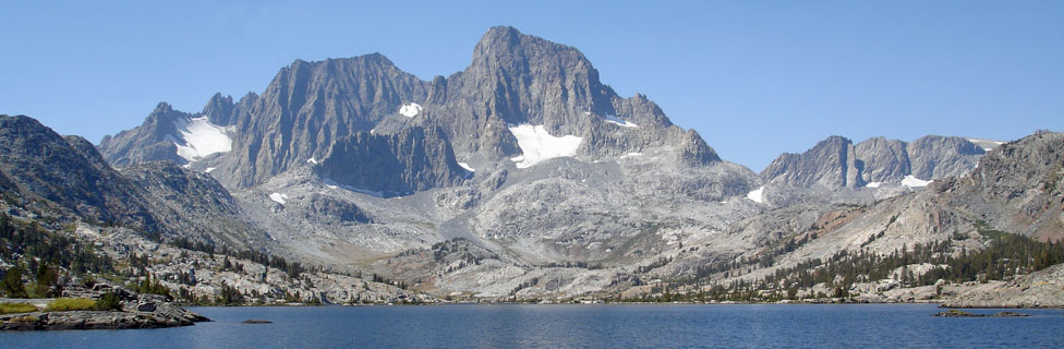
Thousand Island Lake - Banner Peak

Beautiful Thousand Island Lake is naturally a popular camping spot. No camping is permitted within a quarter mile of the outflow of Thousand Island Lake and its neighbor, Garnet Lake. Campfires are not allowed. The best campsites are on the southwest side of Thousand Island Lake. Other nice camps can be found along the north shore. Camping is also available at Garnet Lake. Fishing is good in the lakes for brook and rainbow trout.
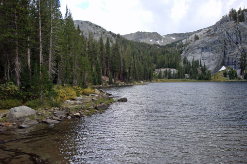

Half Dome, Yosemite National park, California

Rosalie Lake

No camping is permitted at Shadow Lake, so the next best spot is up at Rosalie Lake. Nice campsites are near the lake along the eastern shore. If you follow the outlet stream down a short distance to an overlook of Agnew Meadow you can see all the way south to Mammoth Mountain. Cell reception is possible there. Find more camping opportunities at nearby Gladys Lake. Beyond Gladys, the trail soon begins the long descent to Devils Postpile.


The campground at Devils Postpile has been closed for several years, but there are many other campgrounds up and down the Reds Meadow area. Catch the free shuttle near the ranger station. (Shuttle stops operation soon after Labor Day.)

Side Trips
Along the Way


Marie Lakes

Two excellent side ventures are available soon after descending from Donohue Pass. Marie Lakes are about 2 miles and a thousand feet uphill from the JMT crossing at Rush Creek. Beautiful cascades along Rush Creek highlight the climb. A faint trail leads up the south side of Rush Creek to some small ponds and then veers away, climbing onto the spine of the ridge. Snow can linger on the trail, sometimes as late as early August, making route finding a little challenging. Limited, small campsites can be found near the lake's outlet.

Davis Lake

A second excellent side trip is just down the JMT where a gentle trail leads to the lower of two Davis Lakes. This pretty lake is worth an overnight stay, but campsites with views are limited. Fishing is very good for brook trout. The upper lake is nearby with a 500-foot jump in elevation. Camping is available there, and likely you will find fewer people.

Ediza Lake

With beautiful views of Mount Ritter and Banner Peak, Ediza Lake is one of the most scenic stopping places along the trail. The side-trail to the lake leaves the John Muir Trail at the Shadow Lake junction. Turn up Shadow Creek and climb gradually for 2 miles to the lake's shore. Camping is not allowed on the east or south sides of Ediza Lake. Look for possible sites on the west side.


Shadow Lake

No camping is allowed at Shadow Lake, but it makes a nice stopping place along the trail for lunch and perhaps a little fishing. If you are in need of cutting your trip short, the trail leading out the lower end of the lake connects to Agnew Meadow and the Agnew Meadow Trailhead. Follow the road out to the main paved road and catch the shuttle to stops in Reds Meadow or take the shuttle out to Mammoth Lakes.


Devil's Postpile Trail Map

Tom Harrison maps are among the most popular for Sierra hikers.
Devils Postpile Map