Cottonwood Lakes Backpacking

John Muir Wilderness

photo of Cottonwood Lakes, John Muir Wilderness, California

Cottonwood Lakes Backpacking

John Muir Wilderness


Start Your Adventure at
Cottonwood Lakes

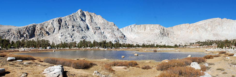
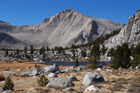
Cottonwood Lakes can be a first night stopping place for hikers setting out to connect to the John Muir Trail or a basecamp for local adventures from fishing to peak bagging. The half dozen Cottonwood Lakes are clustered in a basin at the foot of 14,032-foot Mount Langley (shown above on the right). The lakes themselves are at an elevation of 11,200 feet, surrounded by open meadows, low ridges sprinkled with granite, and swaths of Foxtail Pines.

The 5.9-mile hike to the lakes begins in Horseshoe Meadow, 24 miles southwest of Lone Pine. With the trailhead at an elevation of 10,000 feet, hikers have only a modest climb spread over a fairly easy grade up to the lakes.

Cottonwood  Lakes, John Muir Wilderness, California

Cottonwood Lakes

Cottonwood Lakes - Key Facts


Location: John Muir Wilderness, Inyo County, 24 miles southwest of Lone Pine.
Trailhead: Horseshoe Meadow, elevation 10,050 feet
Cottonwood Lakes: 11,200 feet
Elevation Gain: 1,200 feet
Hiking Distance: 5.9 miles
Difficulty: Moderate
Best seasons: Spring to late fall, depending on snow
Campsites: Sites among trees by many of the lakes; no campfires allowed
Activities: Peak climbing, fishing, photography

sign to Baboon Lakes, 4.5 miles

Wildlife

Bears have learned that Horseshoe Meadow is a good place to search for unattended food, so be sure to use the bear lockers while there. At Cottonwood Lakes, although bears are unlikely visitors at such a high elevation, be wise and use bear canisters to keep your food safe. Deer are seen from time to time. Rattlesnakes are unlikely because of the elevation. Marmots are common around the lakes. Watch for them sunning themselves on the rocks.

Special fishing regulations apply to Cottonwood Lakes, Cottonwood Creek and its tributaries. Use the link below for the most up-to-date Sportfishing Regulations governing the area.


Cottonwood  Lakes trailhead, Horseshoe Meadow, California

Cottonwood Lakes Trailhead


Trekking Poles


Cottonwood Lakes - Key Facts


Location: John Muir Wilderness, Inyo County, 24 miles southwest of Lone Pine.
Trailhead: Horseshoe Meadow, elevation 10,050 feet
Cottonwood Lakes: 11,200 feet
Elevation Gain: 1,200 feet
Hiking Distance: 5.9 miles
Difficulty: Moderate
Best seasons: Spring to late fall, depending on snow
Campsites: Sites among trees by many of the lakes; no campfires allowed
Activities: Peak climbing, fishing, photography

sign to Cottonwood Lakes

Cottonwood Lakes Trailhead:
Horseshoe Meadow

The trailhead for Cottonwood Lakes is at Horseshoe Meadow. From Lone Pine start up the Whitney Portal Road, but after 4 miles turn left onto Horseshoe Meadow Road. After several miles the road begins to climb, soon making switchbacks up the steep mountainside. Driving with caution is advised. After 19 miles watch for the turn to the Cottonwood Lakes Trailhead Campground.

Near the campground you will find vault toilets, water, trash receptacles, bear boxes, an information kiosk, and parking. An overflow parking area is nearby.


Nearby Camping and Lodging

Camping at Cottonwood Lakes Campground is designated for backpackers and hikers to use for one night before setting off into the wilderness. Wood collecting is prohibited, so bring your own firewood or purchase a box at the roadside stand along Horseshoe Meadow Road. Cottonwood Pass Trailcamp and an Equestrian Campground are nearby. Trailcamp fees are $6 per night.

For complete information about campgrounds in the area, see Inyo National Forest Campgrounds

Lodging is available back in Lone Pine at various motels. Also consider the Whitney Portal Store & Hostel in Lone Pine. They offer both private and shared rooms.