Big Pine Lakes Backpacking

John Muir Wilderness

photo of Big Pine Lakes, John Muir Wilderness, California

Big Pine Lakes Backpacking

John Muir Wilderness


Backpacking Among the Big Pine Lakes

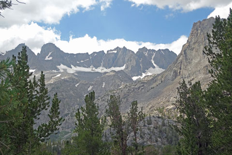
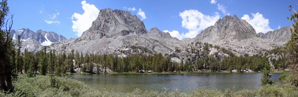
A single day of hiking can place you among the seven varied, and dazzlingly beautiful Big Pine Lakes. The lakes are scattered along a forested, 2-mile alpine valley nestled against the eastern face the Sierra Nevada's Inconsolable Range - a jagged ridge of 13,000-foot peaks.

Big Pine Lakes makes a perfect weekend journey, or to allow time to explore all the lakes and venture up some of the side-canyons, plan on 4 or 5 days. The steep, 4.8-mile hike from road's end takes you up the North Fork of Big Pine Creek, past waterfalls, wildflowers, and an historic stone cabin to First Lake. The lakes have an emerald color caused by the glacial silt washed down from surrounding peaks.

First Lake among Big Pine Lakes, John Muir Wilderness, California

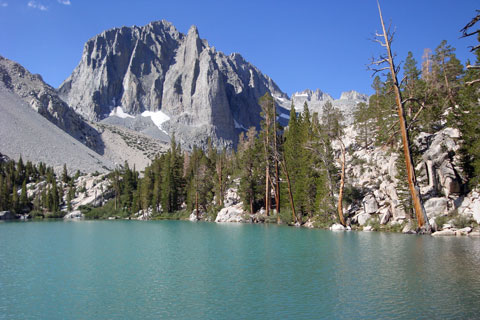
First Lake and Temple Crag

Big Pine Lakes - Key Facts


Location: John Muir Wilderness, Inyo County, 10 miles west of Big Pine, 15 miles south of Bishop.
Trailhead: Big Pine Creek, elevation 7,660 feet
First Lake elevation: 9,957 feet
Elevation Gain: 2,297 feet
Hiking Distance: 4.8 miles to First Lake, 6.9 miles to Fourth Lake
Best seasons: Mid-summer to fall
Campsites: Fourth Lake is most popular, but campsites are found by most lakes.

sign to Big Pine Lakes, 4.8 miles

Artist Robert Clunie

Beginning in the late 1920s, plein air artist Robert Clunie spent summers camped around Fourth and Fifth of the Big Pine Lakes. Just before the beginning of the Great Depression, Clunie hired a mule packer to transport him and his painting gear to Fourth and Fifth Lakes above the Upper Glacier Lodge in Big Pine Canyon.

For the next fifty years he returned every summer to spend two months painting in his beloved mountains. His paintings of the lakes and peaks of the area only gained popularity after his death in 1985.


glaciers above Big Pine Lakes, John Muir Wilderness, California

Glaciers on Slopes of Thunderbolt Peak and North Palisade


Trekking Poles


Big Pine Lakes - Key Facts


Location: John Muir Wilderness, Inyo County, 10 miles west of Big Pine, 15 miles south of Bishop.
Trailhead: Big Pine Creek, elevation 7,660 feet
First Lake elevation: 9,957 feet
Elevation Gain: 2,297 feet
Hiking Distance: 4.8 miles to First Lake, 6.9 miles to Fourth Lake
Best seasons: Mid-summer to fall
Campsites: Fourth Lake is most popular, but campsites are found by most lakes.

sign to Big Pine Lakes, 4.8 miles

Big Pine Lakes Trailhead

To reach Big Pine Creek, turn west onto the Big Pine Road in the small community of Big Pine on Highway 395, about 15 miles south of Bishop. Follow the paved road 10 miles, watching for the Hiker's Parking area for the trailhead on the right.

There is a vault toilet beside the trailhead parking area. The trail to Big Pine Lakes strikes out directly from the parking area along the side of the hill soon connecting with the North Fork of Big Pine Creek.

If time allows, day hiking up the South Fork of Big Pine Creek makes an interesting side trip.


Nearby Camping and Lodging

Big Pine Creek has several campgrounds near the trailhead, all of which accept reservations: Inyo National Forest Campgrounds

Also at the trailhead is Glacier Lodge. Although the lodge building burned down in 1998, they still have cabins for rent, a campground best suited for RVs, a free trout pond, store, and showers available to the public during the day for a modest fee.

Parking

The Hikers' Parking area just off the main road near the pack station is the best choice for overnight parking. Most other spots near the end of the road are for day parking only.